 Service


3D Tiles (Cesium Standard)
3D Tiles (Cesium Standard), as an open standard, defines methods for streaming transmission and visualization of large-scale 3D geospatial data on the web. Proposed and open-sourced by the Cesium team, it has now become an OGC (Open Geospatial Consortium) Candidate Standard and is widely used in digital cities, smart campuses, geological exploration, and other fields. Its core design employs a Hierarchical Level of Detail (HLOD) structure, which uses spatial partitioning algorithms to divide 3D models into multi-resolution tiles. This supports dynamic data loading based on the view frustum range, effectively addressing issues in traditional 3D models such as excessive memory usage and rendering lag in browsers.
2025-11-24 14:49:58
DGN (MicroStation Native Format)
DGN (MicroStation Native Format) is a CAD file format developed based on Microsoft's OLE2 file structure, primarily used in 3D, BIM, and GIS industries. Developed by Bentley Systems, this CAD format is designed for recording and exchanging design data, offering a comprehensive data model and multi-layer drafting capabilities while supporting operation across multiple platforms.
2025-11-24 14:39:21
NTF (Ordnance Survey National Transfer Format)
Ordnance Survey National Transfer Format (NTF) is a spatial data exchange format developed by the Ordnance Survey (OS) of Great Britain. It is primarily used for the transfer and sharing of cadastral and topographic data. Based on the ISO 8211 standard and employing a binary encoding scheme, it facilitates efficient two-way transfer of national surveying and mapping data between local and central government systems. Its design incorporates three layers—physical file structure, logical model, and application protocol—ensuring the preservation of topological relationships and coordinate system compatibility during data conversion.
2025-11-24 14:30:27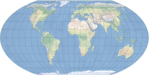
Wagner IV Projection
Wagner IV Projection is an equal area pseudo cylindrical map projection proposed by Karl Wagner, suitable for world map drawing. Its characteristics are that the longitude is an elliptical curve, the latitude is a straight line, the poles are straight and half the length of the equator, it can maintain equal area but has distortion in shape and angle, especially suitable for small-scale equal area world maps.
2025-11-05 16:06:49
Vertical Near-side Perspective Projection
Vertical Near-Side Perspective Projection is a perspective projection method that observes the Earth from a limited distance (such as a satellite or high altitude) vertically downwards. It simulates the visual effects of the human eye or camera through the center projection method, presenting a sense of depth from near to far. It is commonly used for visualizing satellite images or 3D maps, which can enhance spatial depth perception. However, due to the convergence of projection lines at the viewpoint, it cannot maintain the actual size of objects and is only suitable for intuitive display rather than precise measurement.
2025-11-05 16:03:32
Two-point Equidistant Projection
The latitude and longitude network of a 2-point Equidistance Projection typically exhibits complex curves that do not maintain symmetry, with deformations in shape, area, and direction, but can preserve the true distance between two selected points and other points. The National Geographic Society of the United States once applied it to map Asia, while Bell Telephone System Company used an improved version to calculate long-distance telephone rates. The projection parameters include the east offset, north offset, and latitude and longitude coordinates of two points, and only support spherical models. Elliptical models cannot fully maintain equidistant properties. When two projection points coincide, the projection is transformed into an equidistant azimuthal projection.
2025-11-05 16:01:53_1762329695056.png)
Times Projection
Times projection is a compromise pseudocylindrical map projection developed by John Moir in 1965 for the British cartographic company Bartholomew Ltd. It is based on a modified Gall stereographic projection, but with meridians as curved lines rather than straight lines.
2025-11-05 15:59:59_1762329551232.png)
Peirce Quincuncial Projection
Peirce Quincuncial projection is a conformal map projection that presents the globe as a square frame, with the equator displayed as a rotated square centered on the North Pole. Its core characteristic is accurate local shape and orientation (conformal properties), but angular distortion occurs at the center of the four sides. The projection supports seamless tessellation, or mosaicking, allowing the construction of a continuous world route network by stitching together multiple tiles. This projection is particularly useful in aviation and maritime applications, where a coherent view of global navigation routes is required.
2025-11-05 15:58:30_1762329480207.png)
Patterson Projection
Patterson projection is a compromise cylindrical map projection designed by Tom Patterson. Its structure of equally spaced meridians and symmetrical parallels achieves low distortion in the equatorial region while optimizing the shape of high-latitude regions (superior to the Miller projection). Although it is a non-equal-area projection and only supports spherical models, its visual balance and compatibility with mainstream GIS platforms such as ArcGIS make it widely used in scenarios that do not require precise area calculations, such as education and popular science, time zone display, and thematic mapping of areas around the equator.
2025-11-05 15:57:26
Loximuthal Projection
Loximuthal projection is a pseudocylindrical map projection proposed by Carl Simon in 1935. Its core characteristic is that rhumb lines (loxagonal courses) from a central point (the intersection of the central meridian and the central parallel) are displayed as straight lines, while maintaining true bearing and scale. The projection is neither equal-area nor conformal, but was originally designed to provide accurate compass bearings for maritime navigation while clearly defining local shapes by accurately representing course and distance from a central point.
2025-11-05 15:56:34