 Service

Revit File
Revit files are design files created using Revit, a BIM (Building Information Modeling) software developed by Autodesk. It is unique in its ability to integrate and manage 3D models and design information used in the fields of architecture, structure, and engineering (MEP). It is widely used in the construction industry around the world and is a core component of the BIM workflow that covers the entire life cycle from building design to construction and maintenance.
2025-09-16 14:48:07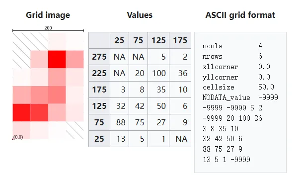
Esri Grid
Esri Grid is a type of raster data format developed by the Environmental Systems Research Institute (ESRI) in the United States. It is a format that is mainly used as a standard in the ArcGIS product group and is used to divide geospatial information into a grid and manage it. Numerical information (elevation value, classification code, etc.) is stored in each cell, and it is used in a wide range of GIS (geographic information system) applications such as topographic analysis, land use classification, and climate data analysis.
2025-09-16 14:48:07
TPK (Tile Package)
TPK (Tile Package) file is a file format for packaging raster or vector map tiles used by ESRI’s ArcGIS platform. It is mainly used for viewing maps offline or embedding maps in applications, and the extension is “.tpk”. Tiles are a collection of images that divide a map or aerial photo into different zoom levels, and TPK is a single compressed file containing all these images.
2025-09-16 14:48:06
LERC (Limited Error Raster Compression)
LERC (Limited Error Raster Compression) is a lossless and lossy compression algorithm for raster data developed by ESRI. It is mainly used in GIS and remote sensing fields, and is optimized for raster data with continuous floating point or integer values. Unlike other image compression formats (JPEG, PNG, etc.), the goal of LERC is to “maximize the compression ratio while maintaining spatial accuracy.”
2025-09-16 14:48:06
JPEG 2000 (Joint Photographic Experts Group)
JPEG 2000 is one of the international standards for image compression and is an improvement on the traditional JPEG (ISO/IEC 10918). It was standardized as ISO/IEC 15444 in 2000 and achieves high compression ratio and high image quality by adopting wavelet compression technology.
2025-09-16 14:48:05
WB (Web Bundle)
WB files are a special format used in spatial data processing software to support web-based spatial slicing services. This format is particularly used to save and publish terrain data or image data after slicing. As a form of integrated management file, it enables efficient loading and online publishing of data. As a self-contained data package containing the hierarchical structure and metadata of terrain or image slices, WB files are widely used in lightweight deployment scenarios.
2025-09-16 14:48:04
XML (Extensible Markup Language)
XML (Extensible Markup Language) is a markup language used to describe and store structured data. Its tag structure is similar to HTML, but its purpose is specifically for expressing and exchanging data, and users can define their own tags. It is mainly used for data integration between systems, setting files, configuration information, etc.
2025-09-16 14:48:04
OGC GeoPackage
GeoPackage is a lightweight, high-performance geospatial information exchange and storage format standardized by the Open Geospatial Consortium (OGC). Unlike traditional multi-file formats such as Shapefile or GeoTIFF, GeoPackage stores all spatial and attribute data in a single SQLite database file (.gpkg extension). GeoPackage is designed for mobile devices and web applications, and is particularly suitable for environments with limited storage capacity and performance.
2025-09-16 14:48:04
PCIDSK (PCI Geomatics Database File)
PCIDSK (PCI Geomatics Database File) is a geospatial data file format developed by PCI Geomatics of Canada, mainly used in the fields of remote sensing and geographic information systems (GIS). The format uses a database-like structure that can store vector and raster data in a single file and is known for its high compatibility with the PCI Geomatics product “Geomatica” software.
2025-09-16 14:48:04
MVT (MapBox Vector Tile)
**MVT **(MapBox Vector Tile) is a map vector tile format developed and launched by Mapbox. It uses vector data slicing and compression technology to cut geographic data into small vector tiles for fast loading and rendering in web maps and mobile applications.
2025-09-16 14:48:03